Canadian cities during COVID-19: did rents go down in transit-rich neighbourhoods?

Mobilizing Justice’s Prioritizing Populations working group has a forthcoming report on the impacts of the COVID-19 pandemic on transportation inequities in Canada. As part of that work, which is due out in May 2022, we examined how the pandemic impacted housing affordability in Canadian cities.
Some research suggests that housing unaffordability is a major factor in transportation inequity in Canada, as people on low incomes and those who cannot afford a car are priced out of neighbourhoods with high levels of transit service and cycling infrastructure. The COVID-19 pandemic, however, held the potential to reverse some of these trends by shifting housing demand pressures to suburban communities. To examine this potential, Mobilizing Justice researchers mapped changes in the median rent for two bedroom apartments from the Canada Mortgage Housing Corporation’s Rental Market Survey. The source data can be found here. Taking the percent difference between October 2021 and October 2019 data, the researchers produced the following map below. The authors overlaid ferry, rail, LRT and subway lines to identify any transit-rich neighbourhoods where rental affordability might have improved.
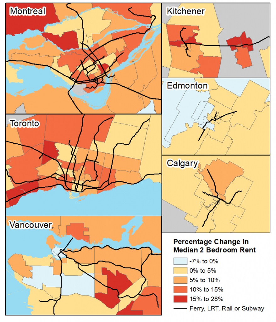
CHMC data indicates that rents declined in only a small number of markets with rapid rail access. These include the downtown, southeast, and west side of Vancouver, and the University market area in Edmonton. Rents continued to rise in transit-rich areas elsewhere, with increases as high as 28% in markets like Plateau-Mont Royal in Montréal, and 19% in Kitchener’s west. These data tell only part of the story, as trends in apartment sales prices may show different patterns. However, renters in Canada are more likely to be on low incomes, and so examinations of rental affordability are relevant to whether people on low incomes are able to afford to live near transit infrastructure.
This map is reprinted from an upcoming Mobilizing Justice report. Want to get notified when this report, and other MJ products, become available? Sign up for our newsletter using the form at the bottom of this page.
You may also like
 What can we learn from a Bike Bus program in rural Nova Scotia?
There’s a revolution happening in the rural community of Hebbville, Nova Scotia (Mi’kma’ki) and it’s accompanied by a healthy dose of bike joy. Since 2020,… Read More
 Removing Fare Barriers: Free Public Transit for Youth Experiencing Homelessness in Toronto
Noah Kelly is the Director of Research & Partnerships at the Transit Access Project (TAP) and has recently completed his Master of Arts at McGill… Read More
 The Hidden Price of Clean Transportation
Lessons from the Transition to Electric School Buses The French version of this blog post is available HERE. Canada’s 51,000 school buses… Read More