How choosing a model may change transit investment plans
Elnaz Yousefzadeh Barri et. el. (2022) analyzed building an accurate model of travel behaviour based on individuals’ characteristics and built environment attributes. They mainly explored the travel behaviour responses of low-income individuals to transit investments in the Greater Toronto and Hamilton Area, Canada, using statistical and Machine Learning (ML) models. They further empirically investigated the proposed transit investment by each algorithm and compare it with the city of Brampton’s future transportation plan.
In Figure 3 of their research, you can see how different models predict the average number of new transit trips after incrementally increasing accessibility for low-income zero-car individuals.
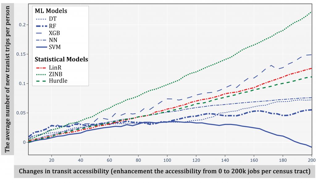
Disregarding the special case of XGB, all statistical models act as an upper bound for the ML models, claiming a significantly higher sensitivity of low-income carless households to transit investment.
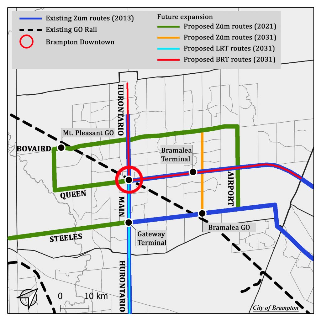
They mapped those values for the specific case of Brampton to better investigate the spatial difference in models’ predictions for the low-income carless community. Fig. 10 in their research shows the existing network of Brampton in 2016 and its recommended rapid transit and transportation network by 2031. Low-income households are mainly located in Brampton central, hosting connections between regional and local transit networks. Northern Brampton, on the other hand, is the least serviced region in the city, where still some transit-dependent low-income households are living. The city planned to extend the Züm BRT corridor to Queen West Street and Bovaird Drive by 2021; however, due to the COVID-19 pandemic, it is only partially implemented by 2022. The existing Züm facility mainly operates in mixed traffic, whereas the city plans to dedicate the exclusive lanes for the BRT in Northern Hurontario and Queen East streets by 2031 (See the red line in the below figure). This extension makes northern Brampton more accessible.
After explaining the existing plan, they show the spatial distribution of newly generated transit trips in the city of Brampton based on different algorithms. The interesting point for Brampton is that although ML models generally suggest lower sensitivity of low-income households to transit improvement compared to statistical ones (see the first figure), in Brampton, it is the other way around. The below figure clearly demonstrates a higher number of new transit trips suggested by the ML models after transit enhancement in this region. Most of these new transit trips belong to downtown Brampton and its city center. The results show that ML models predict significant new trips along a corridor stretching from downtown Brampton to the east (and north and south for SVM and NN) after transit investments. On the other hand, statistical models barely suggest new transit trips by the low-income carless community.
They suggest that one potential reason that the ML results look so different from the statistical model results in the Brampton area is that the regional-scale dataset and models employed are dominated by observations outside of the Brampton area. It appears that the ML algorithms are better able to make more nuanced local forecasts, given their non-linear structures. Future work is needed to investigate further.
You can refer to their research and read more about their approach to interpreting the machine learning models, which are considered “black box” algorithms.
References
Barri, Elnaz Yousefzadeh, Steven Farber, Hadi Jahanshahi, and Eda Beyazit. “Understanding transit ridership in an equity context through a comparison of statistical and machine learning algorithms.” Journal of Transport Geography 105 (2022): 103482. https://doi.org/10.1016/j.jtrangeo.2022.103482.
Disclaimer: the research described in this piece was not funded by or conducted as part of Mobilizing Justice. The views and opinions expressed here are those of the authors and do not necessarily reflect the views or positions of Mobilizing Justice.
You may also like
 Making it safe, Making it work, and Making it fun: strategies for cycling with young children in Hamilton, Canada
Getting around by bike with young children is not always easy. Children are heavy, family schedules can be busy, and children often need to be… Read More
 What can we learn from a Bike Bus program in rural Nova Scotia?
There’s a revolution happening in the rural community of Hebbville, Nova Scotia (Mi’kma’ki) and it’s accompanied by a healthy dose of bike joy. Since 2020,… Read More
 Removing Fare Barriers: Free Public Transit for Youth Experiencing Homelessness in Toronto
Noah Kelly is the Director of Research & Partnerships at the Transit Access Project (TAP) and has recently completed his Master of Arts at McGill… Read More